
What happens to Oregon’s tidal wetlands with sea level rise?
Tidal wetlands provide food, shelter, flow dampening, flood attenuation, and sediment capturing for wildlife. these wetlands are vulnerable to sea level rise (SLR).
The MCWC modeled the impacts of six SLR scenarios in 23 Oregon estuaries south of the Columbia. The resulting products include: a final report and slide show presentation; shapefiles of information of impacts of each SLR scenario for each estuary, prioritization information and metadata for users with GIS expertise; maps of the 4.7' SLR scenario, a prioritization for each area using this SLR scenario, and tables that shows the acreage of tidal wetland areas lost under each scenario.
These tools will help watershed councils, land trusts, soil and water conservation districts, coastal city and county planners, and state and federal agencies plan into the future by working with landowners of properties upslope of current wetland areas on conservation and restoration opportunities. They also provide a valuable opportunity for the public to learn more about how our coastlines will change.
example: siletz bay

Potential future tidal wetlands maps provide a comparison of the 4.7 feet of SLR scenario and the current landscape.
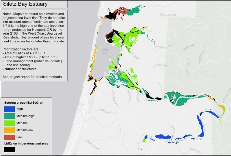
Prioritization maps for each estuary show the Landward Migration Zone area priorities based on the five scoring criteria (See final report for full scoring criteria).

Bar charts for each estuary show the current (0.0 feet) LMZ area in acres, as well as the expected LMZ areas under six sea level rise scenarios.
