Restoration Projects
Restoration work is as much an art as it is a science, and it is never truly finished until natural processes are restored.
Culvert replacements, large wood placements, dike removals, invasive species management, and riparian planting and fencing are just some of the actions we take on the ground to restore habitat so that it can sustain salmon and steelhead—and all the other beings that depend on them. It takes a delicate balance of understanding site characteristics and working in partnership with other organizations, agencies, and landowners to see these tasks through.
However, years after these exciting projects wrap up, we still keep our eye on them to ensure that the actions we took are working to achieve the desired goal. Many lessons are learned along the way, and we are happy to share them with you. The project summaries below follow in order of occurrence, with the most recent work on top.
yaquina estuary

Over summer 2020, a tidal wetland restoration project will begin, viewable from across the Yaquina River on Elk City Road near Cannon Quarry Boat Launch. MCWC and partners are working to improve habitat for coho, chum and Chinook salmon, with activity at the site beginning in July and wrapping up in September. The project takes place on a site called Y27, owned by The Wetlands Conservancy.
Young coho, chum and Chinook salmon benefit greatly from having tidal marshes they can rear in. Research in the Salmon River estuary near Lincoln City showed that after most of marshes in that estuary were restored the young coho that had spent extended periods of time in those habitats accounted for a full 20–35% of the adults returning to spawn a few years later. Similarly, but to an even greater degree, more than 50% of the returning adult chinook salmon had also spent more time as young salmon in the nutrient rich and protected waters of the estuary. Juvenile chum salmon utilize estuary habitat almost immediately after emerging from spawning gravels. While fish habitat is the main reason we’re expanding the restoration work that was done in 2001, we’re also trying to remove more of the dikes and create new tidal channels so the site can store more water during floods, accumulate more sediment to keep up with sea level rise, and restore forested tidal wetland habitat.

Most, but not all of the dike you see, will be lowered to marsh surface level. We will strategically protect spruce, planted during the 2001 project, on remaining portions of the dike. The soil removed from the dike and from the channels we dig will be used to fill the straight drainage ditches on the site and create some elevation diversity. You will also see us placing a lot of large logs and root wads into the channels and on the marsh to increase cover and habitat for fish. Additionally, we’ll be working to restore some spruce swamp habitat on the site and to control invasive weeds.
The location diagram and the overall work plan for the project is shown at left. Both the City of Toledo and the Confederated Tribes of the Siletz Indians are partnering on the project and we have all the necessary permits in place from Lincoln County, Oregon’s Department of Fish and Wildlife, Department of Environmental Quality, and Division of State Lands, as well as a federal permit from the Army Corps of Engineers.
Funding for this work was received from the Oregon Watershed Enhancement Board, the US Fish and Wildlife Service Fish Passage Program, with additional support from the Pacific Marine and Estuarine Fish Habitat Partnership and the Oregon Wildlife Foundation. Project partners include the City of Toledo, the Confederated Tribes of Siletz Indians, the Wetlands Conservancy, Pacific States Marine Fisheries Commission, Oregon Department of Fish and Wildlife and US Fish and Wildlife Service Partners for Fish and Wildlife.
To learn more about the project, check out its coverage in the local news:
The Register-Guard, June 27, 2020: https://www.thenewsguard.com/community/yaquina-estuary-restoration-project-will-begin-this-summer-providing-benefits-to-salmon/article_e96e8324-b7cf-11ea-90d9-4f6e1f4aba20.html
Newport News Times, August 25, 2020: https://newportnewstimes.com/article/salmon-project-continues-on-yaquina-river
Project updates will be shared below as work progresses.
August 19th Project Update

This past week, in preparation to fill a large man-made drainage ditch to force water into narrow, winding channels, typical of natural wetland system, Oregon Department of Fish and Wildlife personnel were out on the site, removing fish and transporting them to safe areas. Over 300 sculpins and sticklebacks were successfully transferred out, so that filling the ditch and placing trees with roots at critical junctions could proceed before the tide came back in.
In addition, a lot of grading and soil removal was done to achieve an appropriate elevation for allowing tidal flow back in through man made dikes, and new channels were dug.
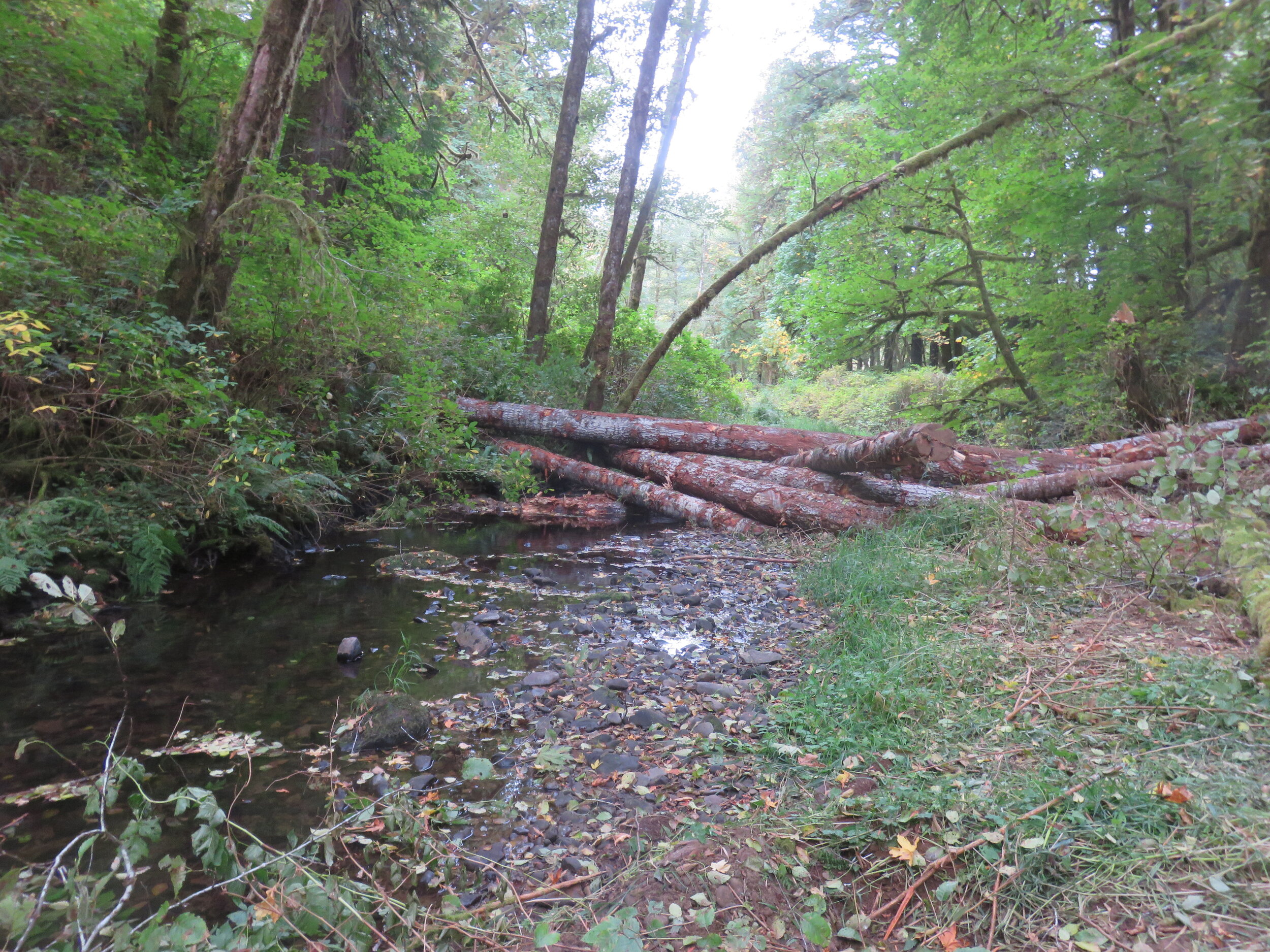
Other work that has occurred so far includes the placement of large wood and tree root balls in strategic areas across the site. This will increase cover for rearing fish, create habitat structure, and in the long term will act as nurse logs for the growth of Sitka spruce trees and other plant species.
Y27 Work Wrapped Up, Featured on KLCC
The major on-the-ground work wrapped up earlier than expected on August, 21st. Crews are still on the site de-mobilizing, and of course the seeding is yet to take place this fall after the rains begin. With this bit of quiet at the site, it was great opportunity to talk briefly with KLCC reporter Nathan Bouquet: https://www.klcc.org/post/coastal-wetland-restoration-project-comes-finish
North Creek
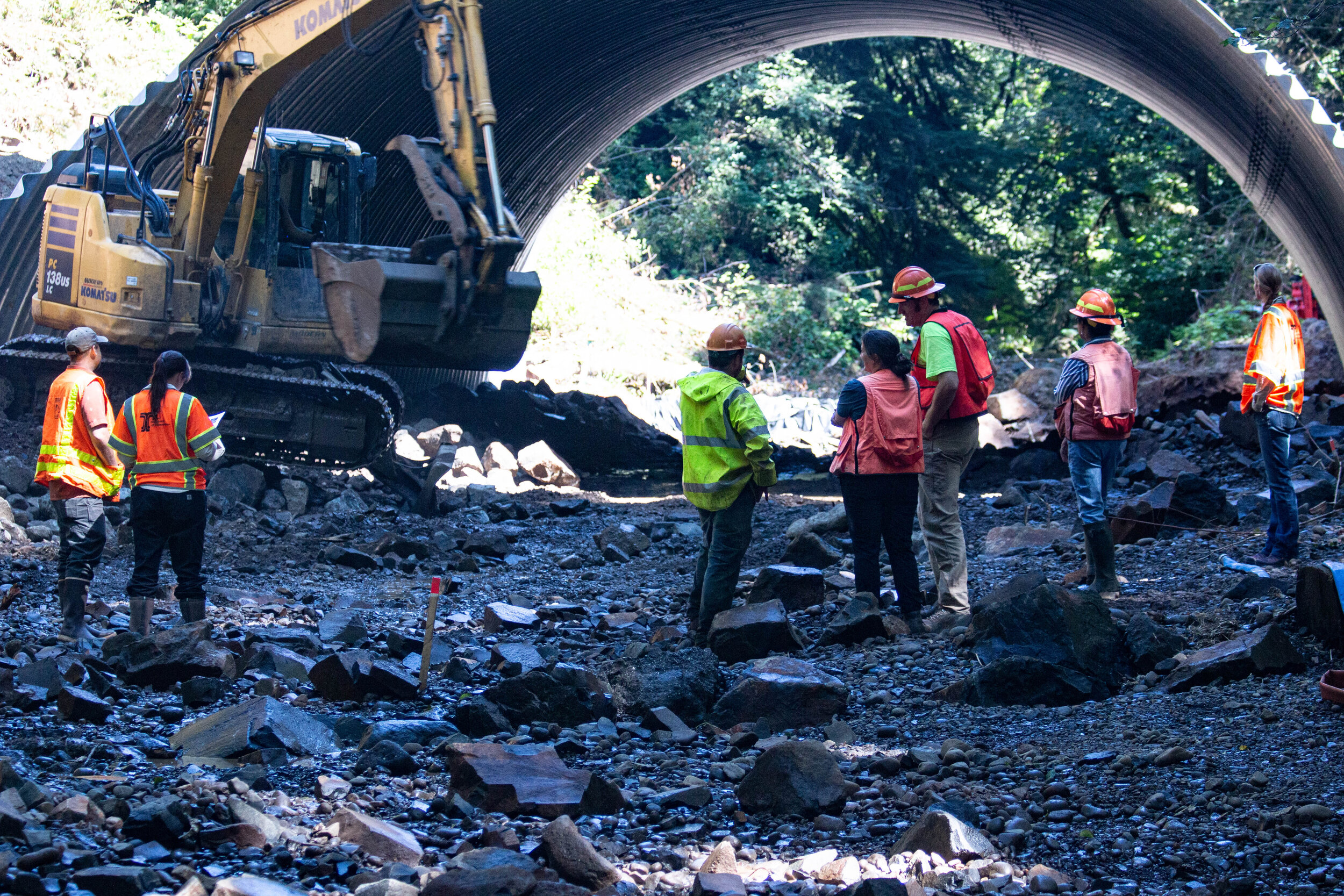
In 2019, a large culvert was put in place on North Creek, a tributary to Drift Creek in the Siletz River Basin that will allow Chinook and coho salmon, along with steelhead, coastal cutthroat, lamprey, freshwater mussels, and other aquatic organisms to freely access sixteen miles of stream and wetland habitat in North Creek for the first time in 62 years.
The project removed the old, severely undersized and jagged culvert and replaced it with an appropriately sized, open-bottomed structure that doesn’t create a velocity or passage barrier to fish and other animals or to the downward transport of gravel or large wood which will improve also improve salmon spawning grounds downstream. In addition to these ecological benefits, the culvert replacement allows for safe transport to and from popular forest recreation areas and Drift Creek Camp
Other collaborators assisted with funding, including the USFS, the U.S. Fish and Wildlife Service’s Fish Passage Program, Oregon Watershed Enhancement Board, Oregon Department of Transportation-Oregon Department of Fish and Wildlife Fish Passage Program, Trout Unlimited, National Fish and Wildlife Foundation, as well as a crowdfunding campaign organized by the Native Fish Society.

In the fall, students in Oregon Coast Community College’s Freshwater Habitats course will visit the North Creek restoration site six times to determine how the stream simulation changes as it faces its first storm events and identify how organisms like salmon and aquatic insects respond to the newly opened channel. In addition, volunteers with Trout Unlimited will continue eDNA sampling at 13 locations in the North Creek Watershed for two more years to determine the presence of difficult-to-survey target species such as lamprey and freshwater mussels. The efforts of these community partners will be complemented by stream temperature monitoring for three years by the USFS and the Environmental Protection Agency. The data resulting from monitoring work is expected to serve as an example for future large-scale aquatic organism passage projects.
To learn more about this project, check out its coverage in the local news:
The Register-Guard, July 2nd, 2019: https://www.registerguard.com/news/20190702/creek-restoration-opens-homes-for-aquatic-species
Newport News Times, Oct 29th, 2019: https://newportnewstimes.com/article/large-restoration-project-completed
For even more nitty, sometimes gritty, details of what occurred throughout the nearly $1 million project’s timeline, click on the buttons below for bi-monthly breakdowns written by project partners as the work was happening:
Record Creek

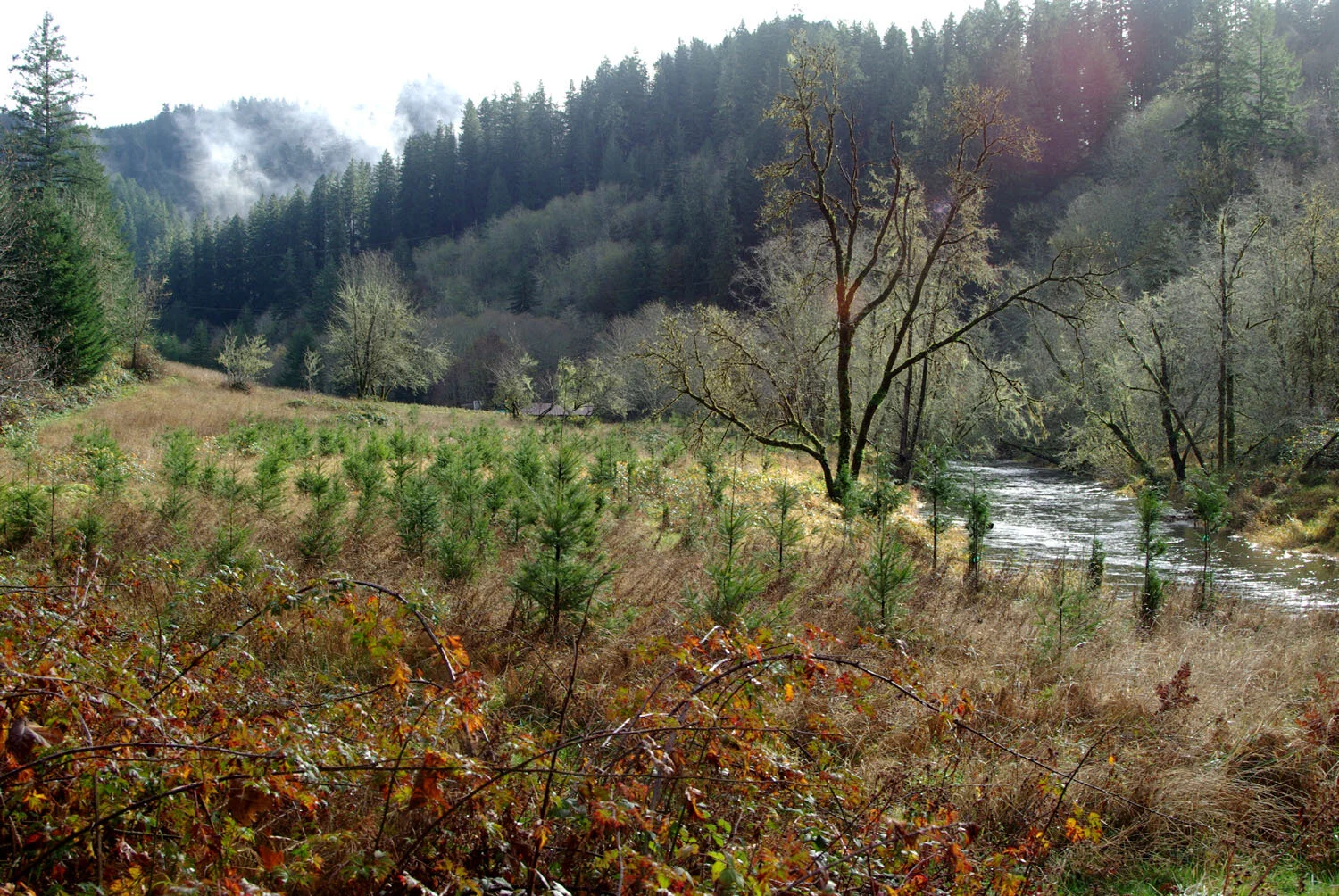
Record Creek is a tributary to Swamp Creek, one of two major branches of the Bummer Creek sub-watershed within the greater South Fork Alsea system. This site, like many other riparian areas across the Northwest, was historically cleared up to the stream. Eventually alders colonized the area, dominating the forest canopy and stalling later stages of forest from developing. While alders adequately provide the important function of shading the stream, their logs degrade quickly when they fall instream and do not contribute to creating the habitat complexity that fish and wildlife rely on to the degree that native conifers like Western red cedars do.
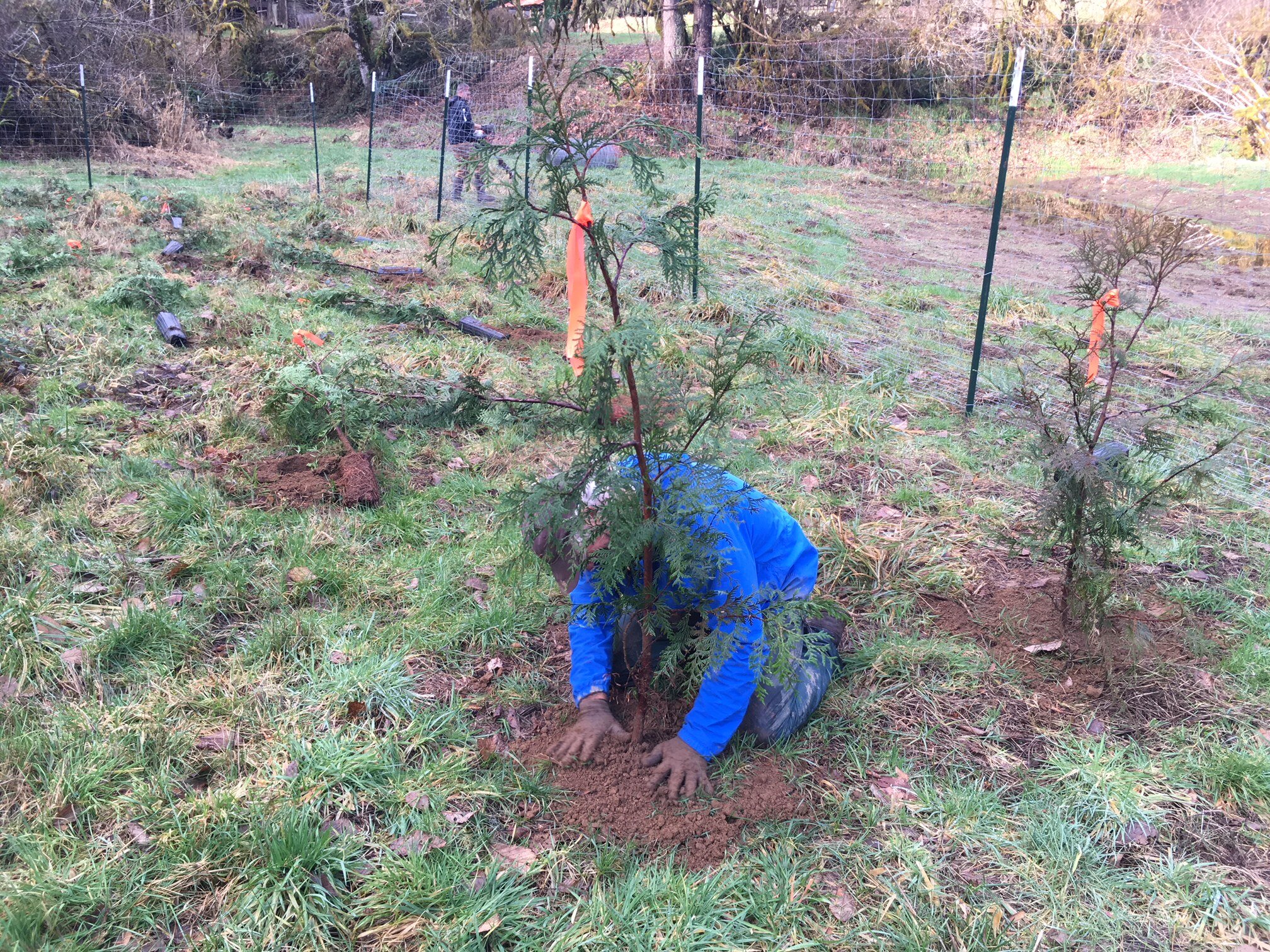
With funding from OWEB and log donations from BLM, in 2019 MCWC and placed 5 logjams over a 0.3 mile reach of Record Creek in order to trap and sort spawning gravel, form pools, and increase overall habitat complexity and floodplain connection. To provide an even longer term source of large woody debris to the stream, volunteers helped in planting 150 native Western red cedars in the alder-dominated riparian area of Record Creek. These trees will never be cut down, and will continue benefiting the habitat throughout their lifespan and beyond.
Little Lobster Creek
The project took place in the lower reaches of Little Lobster Creek, with restoration activities seeking to address two limiting habitat factors for salmonids in the watershed—with a particular emphasis on Oregon Coast coho, listed as threatened on the Endangered Species Act—elevated summer stream temperatures and a lack of instream wood, as identified by a 1997 USFS Watershed Analysis, and again in a 2006 Limiting Factors Analysis MCWC contracted out to BioSurveys LLC.
Due to its warm summer temperatures, which harm juvenile salmon rearing in the stream, Little Lobster Creek is currently on the OR Department of Environmental Quality 303d list for water quality impairment. Meanwhile, the lack of fallen logs in the stream since the days of homestead clearing has led to a loss in the abundance of spawning gravels appropriate for salmonids, since there’s nothing in the creek to keep gravel from washing downstream during large storm events.
To address these limitations, MCWC and partners (including a team of volunteers) reestablished native conifers in the riparian area for long term shade and wood recruitment to the stream, and placed a significant amount of large wood within the channel to trap migrating substrate in the spawning grounds. The Siuslaw Collaborative Watershed Restoration Program and Oregon Watershed Enhancement Board funded the implementation of this work and the project management, and a large match was also secured from the BLM through donating wood used in the project.
Bummer Creek
Bummer Creek is located in the Alsea River watershed, and has been the target of numerous restoration projects over the past 5 years. It was identified in an OWEB-funded Limiting Factors Analysis (LFA) as temperature and gravel limited. To address these issues, riparian planting, livestock exclusion fencing, culvert replacements and instream large woody debris placements have been implemented on a suite of 8 cooperating small private landowners within the sub-basin.

The LFA also classified the lower mainstem as highly incised and limited by truncated linkage to historical off channel rearing habitats. Both the USFWS and the MCWC have been instrumental in the development of salmonid accessible off channel wetland habitat in partnerships on the Parker property as part of this larger basin scale effort. LiDAR analysis has revealed the presence of 1.5 miles of diked and inaccessible oxbow habitat.
We extended riparian fencing and planting downstream on Bummer Creek to the next 2 adjacent private land parcels (140 acres combined), reconfigured the wetland outlet to exit through its historical channel, and developed additional wetland habitats to store and retain winter runoff to address the summer temperature limitation in mainstem Bummer Creek.
This is a private landowner partnership with in-kind match contributed from Environmental Quality Incentives Program (EQUIP) and Conservation Reserve Enhancement Program (CREP). Funds supported the creation of approximately 1500 feet of livestock exclusion fencing on the Jackson property, putting 7.7 acres of land into riparian reserve in 2018.
Mill Creek
Working in partnership with ODFW, MCWC completed a restoration project in Mill Creek in the Siletz Basin in 2016. 679 logs were placed in 57 large wood structures in 6.8 stream miles throughout the coho distribution in the sub-basin. The goal of this project was to address limiting factors in the basin of habitat complexity, primarily winter rearing habitat.
This project was followed up by an extensive Effectiveness Monitoring project to determine the effects of the large wood placement on fluvial geomorphology, aquatic habitat, benthic invertebrates assemblages, overwinter survival of juvenile coho, and overall coho smolt production for the watershed.
Partners include: ODFW, Weyerhaeuser, Oregon DEQ, and OSU College of Forestry. The study is designed to inform future in-stream restoration priorities, large wood placement design, land use management, coastal coho recovery goals and objectives, and limiting factors analyses for coho salmon production.
BUCKLEY CREEK
Buckley creek is a direct ocean tributary roughly two miles north of Waldport, Oregon. The creek is occupied by native cutthroat trout, possibly brook lamprey and other aquatic and wildlife species. The site is an important freshwater wetland with beaver pond complexes and a diverse array of habitats. The Buckley Creek watershed area is roughly five square miles.
Previous Federal Emergency Management Agency projects replaced two 48” culverts on Buckley creek in the Silver Sands neighborhood upstream from the project area. These projects left one 48" culvert restricting flow on a private driveway. The culvert underneath this driveway is the last before the stream runs into the Pacific Ocean, just south of Driftwood Beach State Park. The owner has dealt with flooding caused by the remaining 48" culvert in any heavy rainfall event.
To complete this project, we paired a willing landowner with an Oregon Watershed Enhancement Board small grant. The culvert replacement was done in late September of 2016, installing a new 94" squash tube culvert to increase wetland connectivity, alleviate fish passage issues and reduce flooding on adjacent properties.

North Fork Yachats
This project treated approximately 5.5 acres of riparian corridor in the North Fork Yachats Watershed in 2016. Native trees and shrubs were planted and protected from wildlife browse with enclosure fencing. Water bars were installed on abandoned roads to reduce soil erosion and sediment inputs to the watershed, and selected boles of big leaf maple were girdled to create habitat for cavity nesting birds.
Lower Yaquina and North Fork Beaver Creek
This project placed large wood structures in a total of 9 stream miles in the Lower Yaquina River and North Fork Beaver Creek basins, including Wright Creek/Poole Slough, Mill Creek, and Peterson Creek. There were several landowners involved including Siuslaw National Forest, van Eck Forest Foundation, Plum Creek Timber, City of Toledo, The Wetland Conservancy, and private landowners. Most of the large wood was placed by helicopter in fall 2014. ODFW and USFS biologists coordinated and oversaw the wood placement. ODFW’s Habitat Restoration Biologist provided the overall project management and coordination of efforts.
